
Independently Owned, Locally Grown, Community Loved


The Burdekin Shire is being urged to stay informed as a developing tropical low in the north threatens to intensify into a cyclone later this week, adding to already saturated conditions across Queensland.
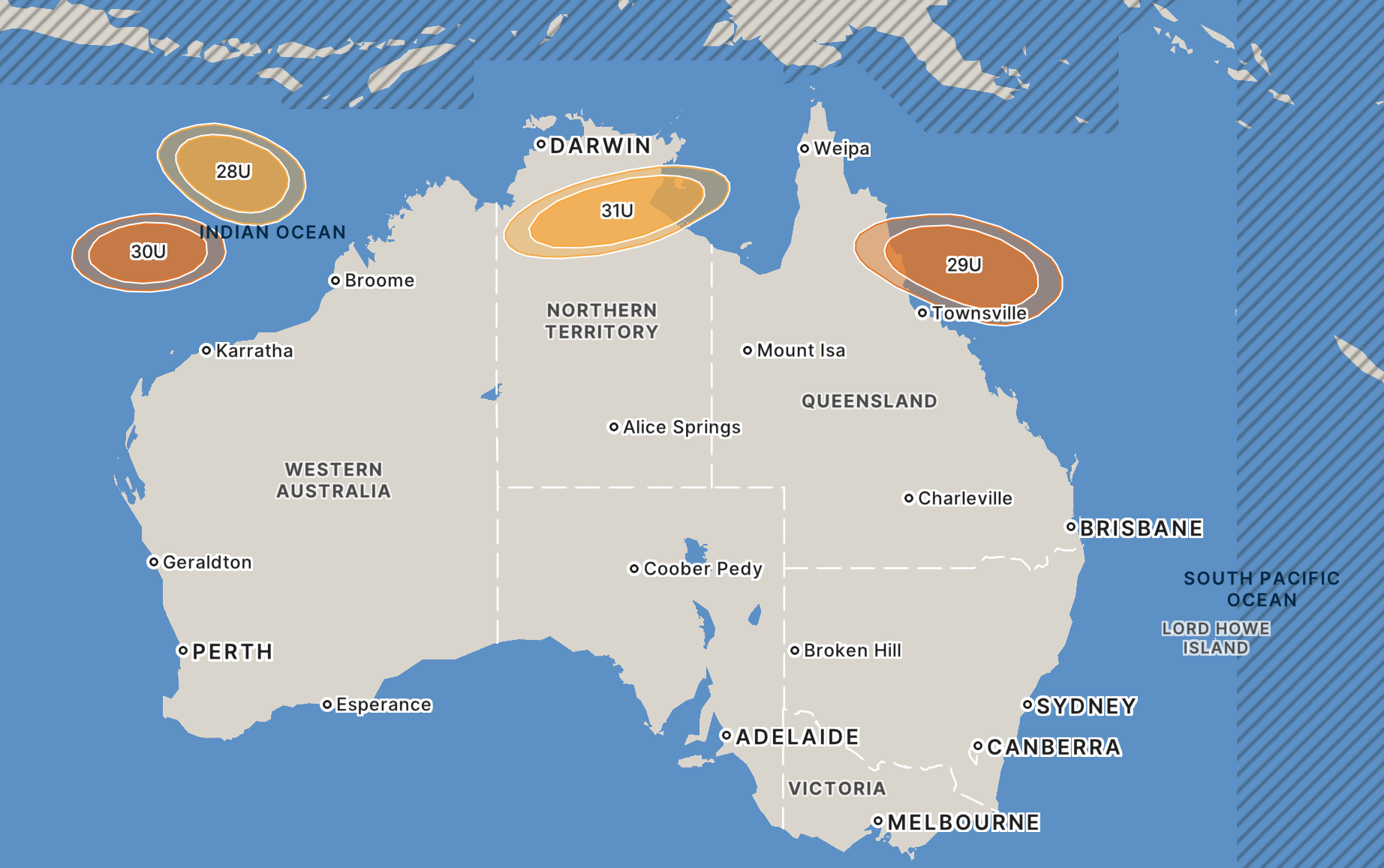
After weeks of heavy rain and flooding across the state’s north and east, attention has turned to a system in the Gulf of Carpentaria being closely monitored by the Bureau of Meteorology. Tropical Low 31U, currently moving over Gulf waters, has a low chance of developing into a cyclone in the coming days, though forecasters say conditions could shift quickly.
Another system, Tropical Low 29U, forming in the Coral Sea, is forecast to move west later this week and could track towards the Queensland coast between Lockhart River and Mackay before potentially moving inland. While the exact path remains uncertain, communities across Northern Queensland, including the Burdekin, are being advised to monitor updates closely.
Locally, the Burdekin Local Disaster Management Group (LDMG) has transitioned back to ALERT status as a precaution. The Australian Warning System message for the Burdekin Local Government Area currently sits at “Advice – Stay Informed”.
Minor flooding has continued along the Burdekin River, with Sunwater confirming the Burdekin Dam was sitting at 3.75 metres and steady above the minor flood level of 3 metres as of Monday, 2 March. At the Inkerman Bridge gauge, river levels are holding at 7.45 metres, also above minor flood level. Both are expected to remain elevated through Thursday and Friday.
Currently, no communities are isolated, and no major impacts have been reported. However, further showers and thunderstorms forecast across the catchment could trigger additional river rises in the coming days. Residents of low-lying areas, including Rita Island, are being reminded they may become isolated if water levels increase.
“With cyclone season still underway, this is a timely reminder for households across the Burdekin to make sure they are prepared,” Mayor Pierina Dalle Cort said.
“While there is still uncertainty around this system, being prepared early makes a real difference. I encourage residents to check their emergency plans, ensure their kits are ready, and stay informed through official sources.
“Council’s Disaster Dashboard and emergency management pages on our website provide reliable, uptodate information, and are the best places to find advice as conditions change. Visit disaster.burdekin.qld.gov.au”
Authorities are urging residents not to be complacent. Roads and access points could quickly become impassable, and drivers are reminded never to enter floodwaters. “If it’s flooded, forget it” remains the standing advice.
Emergency services are encouraging households to take practical steps now while conditions are stable. Preparation starts with understanding your risk, knowing how flooding or cyclonic winds could impact your home, access roads, workplace and children’s schools.
Residents should review or create a household emergency plan, ensuring all family members know evacuation routes, emergency contacts and meeting points. An emergency kit should include at least five days’ worth of drinking water, non-perishable food, medications, pet supplies, torches, batteries and important documents in waterproof packaging.
Now is also the time to secure loose outdoor items, trim overhanging branches and check that gutters and drains are clear. Farmers and business owners should consider contingency plans for livestock, equipment and stock.
Residents are encouraged to monitor the Burdekin Disaster Dashboard, tune into local radio Sweet FM 97.1, and check the Bureau of Meteorology website for the latest warnings. Road closures can be found via QLD Traffic or by calling 13 19 40.
For SES assistance during floods or storms, call 132 500. In life-threatening emergencies, call Triple Zero (000).
With Queensland no stranger to extreme weather, preparation remains the strongest defence. While the cyclone threat is still developing, authorities stress that communities who act early are best placed to weather whatever the coming days may bring.
All information published was current as of Tuesday, 3 March.
BOM predicts systems will continue to form over the weekend. Photo source: BOM
Publishers Indemnity. Any individual or entity that places advertising, supplies copy material, or submits editorial content to Core Life Publishing agrees and undertakes to ensure that all such material:- Does not infringe upon any copyright, trademark, or other intellectual property rights;- Is free from any content that could be considered defamatory, libelous, or slanderous;- Does not infringe upon any rights related to privacy or breach of confidence;- Contains no obscene, indecent, or otherwise unlawful material;- Complies fully with the Trade Practices Act and all other applicable laws, regulations, or statutes.Furthermore, by submitting or placing such material, these individuals or entities agree to indemnify and hold harmless the publisher, Core Publishing and Events Pty Ltd, and/or its agents from and against any and all investigations, claims, demands, liabilities, damages, costs, or judgments arising out of or in connection with the material provided. All material is believed to be accurate at the time of printing and remains the copyright of Core Publishing and Events Pty Ltd.
© 2026 Life Publishing Group Pty Ltd.